Tongariro National Park, NZ


February 9, 2023 - February 11, 2023
As Bridget pointed out in a previous post (Waitomo Caves) due to all the flooding in the area (and the caves) outfitters unfortunately had to cancel all cave related activities the two days that we had originally planned to be in Waitomo and therefore we did our cave related tour on our “transition day”, which caused us to have back to back adventure days here. Side note - we should probably think of a better name for that - we all know what I am talking about - the day that we are driving from one area to the other - we don’t usually plan that much - so from now on we will call that day our DFATANPM day (Driving from area to area not planning much). So on our DFATANPM day we didn’t start to head to the National Park Village until 3pm arriving around 6pm. Our hotel was amazing! It was a cozy 2 bedroom “apartment” in this small motel looking place, which we cooked a nice meal in the unit and watched a Netflix documentary while researching the next days hike - Tongariro Alpine Crossing.
By some miracle I convinced Bridget to do this 12.3 mile, 2500 foot climb (.5 miles up) through this ever changing landscape that included three volcanos, a red crater, beautiful geothermal lakes, and ended through a forest. The hike is continuously rated as the best day hike in New Zealand and one of the top 10 day hikes in the world. The hike is one way meaning you have to arrange someone to pick you up or park at the end of the hike and hire a van to take you to the start of the trail. We decided to hire a van service and booked the first one at 7:00 AM to allow ample time to finish the hike. We arrived at the carpark right at 7:00 AM, and when we got out of the car, we heard the person working the shuttle system shouting randomly. We couldn’t really understand what she was saying, but assumed she was yelling at us since we were the only people in the parking lot. We quickly gather our gear and run around the tree line. Now this run was one of those awkward runs like someone is holding the door open for you, but they are way too far ahead of you, so you skip/waddle toward the door - that kind of run - but for a much longer distance! We turn the corner and see there was absolutely no need to run. The woman was not yelling at us. There was a full bus, 20 people waiting there, and 3 empty buses behind them. We just happened to be the two out of breathe people scrambling for no apparent reason to the bus line while everyone was staring. GREAT START to this hike…
We take the 30 minute bus ride over to the start of the hike and listen to the bus driver as he explains what to expect. Things like - explaining the sections of the hike (there are 6), how we should feel during each, be aware of the weather, and how much water, food, sunscreen, and sunglasses we should have. Oh! I forgot my sunglasses in the unnecessary, chaotic and somewhat embarrassing waddle run we did to the bus - this will be fun.
We get dropped off and the bus driver makes a joke about the only way back home is to walk the 12.3 miles back to our car. “Yipee” says Bridget - with a half grin, half nervous look on her face. We take a picture next to the “Tongariro Alpine Crossing”, take one last look at the map of the route, and start on our way!
The first 3 miles of the hike are through a beautiful rock and heavily grass/shrubby area with the backdrop of Mt. Ngauruhoe. This is the first of three volcanoes that we walked by on this hike, but it was by far the most impressive. In fact, it was the volcano used in The Lord of the Rings to showcase the most evil place in Middle Earth - fiery depths of Mordor chosen by Sauron.


The view after the grassy area where it was old lava rock was pretty amazing. There was even a cloud around the top that hung out there most of the day making the appearance that it was smoking. What wasn’t amazing was the ridiculous climb up and over the mountain. This section of the hike was called “The Devil’s Staircase”, which was as you can imagine - hellish. 370 stairs that was just relentless with no flat sections and seemingly never ended. There was this woman walking in front of us near the end of the “staircase” that just had her head down and looked like Eeyore walking up these stairs. Then I noticed my own posture (and Bridget’s) and we were doing the exact same thing. It felt like we were in slow motion…or a more detailed description had cement shoes and we were stuck in a bowl of pudding. When we finally made it to the top, Bridget and I high-fived, I did this super cool hang 10 sign that I have been doing since Hawaii, and we started through the much deserved flat crater section between volcanoes.
In the flat crater, we stop for a quick romantic lunch of water, ham sandwiches, crackers, & banana at this beautiful lake (that happened to be dry) without a bug in the sky (we got attacked by horse flies the entire time). As we were enjoying our lunch, we pointed out the route we thought we were going to take. It seemed manageable, but as we started to look closer and closer, we noticed people were actually not going toward the manageable route but up another set of stairs/hills. “Can’t wait” Bridget says as we pack up, mentally prepare, and start to head up another rigorous uphill battle.

Even though this section looked rough, it wasn’t as bad as “The Devil’s Staircase”, and Bridget and I navigate with relative ease. We get to the top of the hill and stare down into this beautiful Red Crater with views overlooking what we just hiked and what we are going to continue to hike.
At this point we notice and have read that we are at the peak height of the hike, which means two things, the view is probably pretty spectacular and we are going to have to start heading down the mountain. The decline on this particular mountain was VERY STEEP and had a lot of loose gravel, which was quite tricky to walk through. As we watched the different styles of people walking down the hill, some people were nervously going sideways down, some were walking like Sasquatch (long quick strides) and others were just simply using their hiking poles to keep themselves up. Bridget and I implored the cool guy walk (low butt, knees bent, cool arm swing), which most importantly, if you fell, you’d fall on your butt and not tumble down head first into the volcano crater.

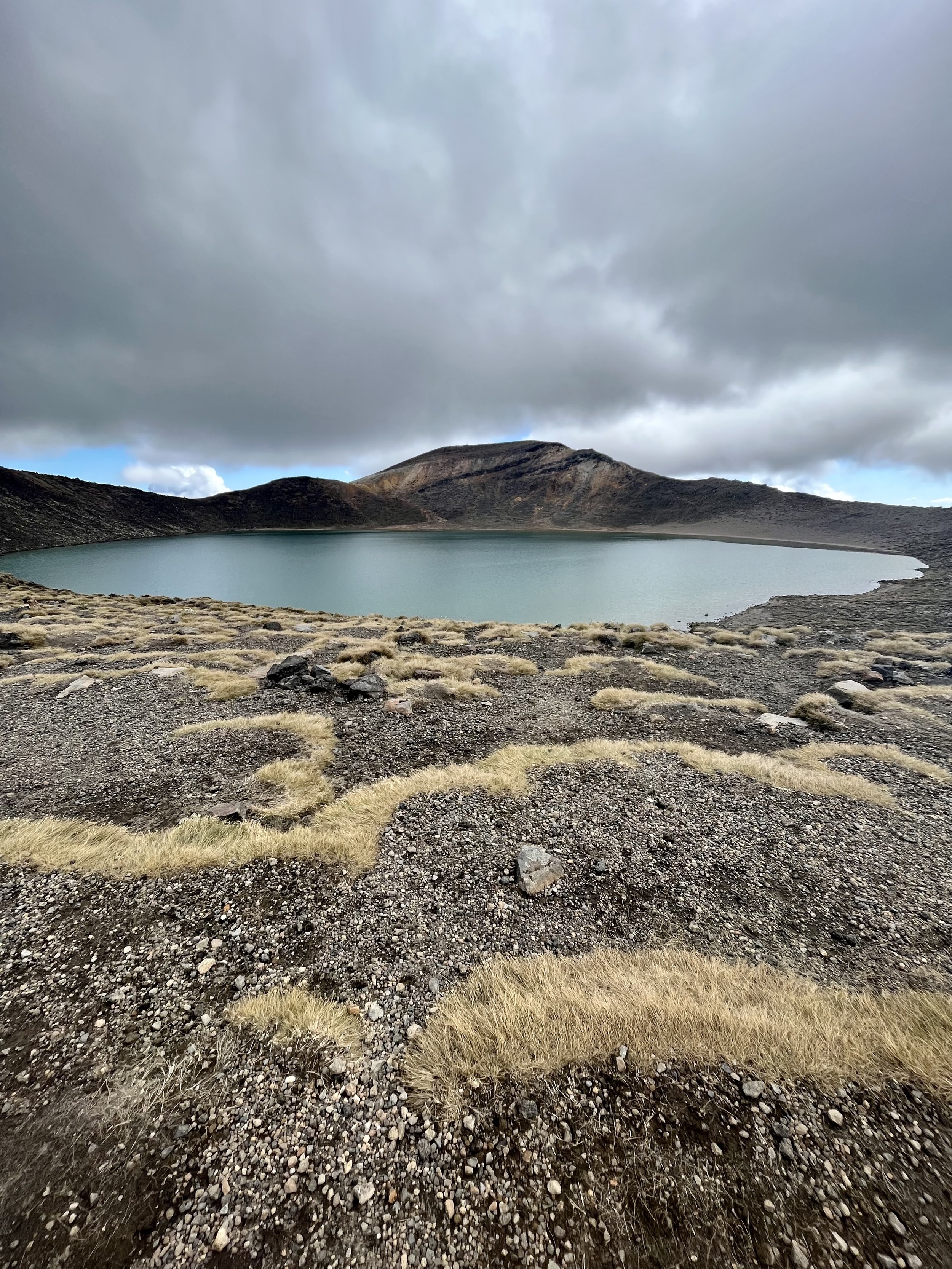
On our way down the steep decline of the crater, we come up to the picturesque part of the hike. Three beautiful geothermal lakes that overlook a magnificent backdrop. This is what you see when you google Tongariro Alpine Crossing and it was totally worth it. Bridget and I stared in awe at the lakes, took multiple pictures, asked random people to take pictures and then stared some more - it was probably the coolest part of any hike I have done.

We take it all in and then head toward another much larger lake. I am pretty sure if we didn’t just admire the previous three lakes for so long, this lake would have (and is) spectacular in itself.
That lake really signified the end of the really difficult uphill battles, but we still had 6 or so miles to go. We come out to the other side of the larger lake and look out over the edge and see, I kid you not, what appeared to be 30-40 switchbacks down the side of this mountain overlooking the beautiful Lake Taupo. I don’t think it would have been that bad if we couldn’t see the endless amounts of switchbacks we had to do. You could literally see the road to our car, but we knew it was 5+ miles away. To pass the time, we made conversation with strangers, discussed wedding plans, walked fast/walked slow, touched all the grass, etc.

We finally made it to the last section of the hike, which was through a heavily wooded section that included a waterfall.

Overall, this hike had such a changing and dynamic landscape that it was a very unique experience to do. I would highly recommend it to anyone going to Tongariro - just start the hike early, know there are going to be hills, and just have fun with it!
On to our next stop…HASTINGS!
XOXO